In case any one was wondering what happened to the jolly gang here at GPSTravelMaps, we are still alive and doing quite well. Life has been getting better since Spring is around the corner and the weather is warming up. Hooray!
We have been working behind the scenes on some unique projects that we hope to offer soon. They will be useful for all those traveling in South Africa this year, so we hope to complete them for distro soon.
Sorry about the slow updates on the site, but we haven't given up on this project, just preping from some cool stuff in the future. Until than, keep exploring.
GPSTravelMaps.com
13 September, 2006
16 August, 2006
Technical Hic-ups
Ok, this week we have faced a slight delay in our development. My home internet service went down last week and I had to wait a week for a tech to come and sort it out at the telecom's exchange. So updates have been non-existent. Sorry for that.
The response to the Mt. Kilimanjaro map has been good so far. Please post or email us your comments, so we can improve it. There was a bad link for the file at first, but we sorted that out quickly. Sorry for that as well.
We have doubled our computing power here at home base. This means that we can now create more maps in less time. So watch out for these coming through the pipeline.
Thanks for all the support and we look forward to where this project takes us.
06 August, 2006
New Data Soon!!!
It has been a little over a week since the last data update on the site. We have been hard at work sorting things out with the format of the site and also with some of the map products that we have on offer now. Things are moving ahead though.
I have just finished creating the Mt. Kilimanjaro Topographic map tonight. As far as I can tell, this is the first GPS contour map of the mountain available to the public, so we are quite pleased with this offering. The file size is just under 1.5 megs for the map, which will work nicely within your GPS. The map is considered a version 1.0, however we realize that there is a little bit more work to be done on it. Depending on the popularity of the map, we will spend the time updating the data in those small areas, but we felt like we wanted to get working on some of the other maps for now. So let us know what you think of this map and if you want us to spend more time on it.
I plan on putting this map up on the site within the next day, so please be patient while I get some other things finished as well. Take care and happy mapping.
27 July, 2006
New Data Available Now
Our first major release of data was completed last night. We are happy to announcce that we now have two Garmin GPS city mapsets, one Garmin topographic mapset and five hiking tracks available for download immediatly.
The two city mapsets are:
Cape Town, South Africa
Las Vegas, USA
The topographic map is for the Cape Town Metro area.
The hiking trails are for walks through Table Mountain National Park. They consist of:
Constantia Corner
Lions Head
Woodstock Cave
Swartkopberge
Sentinal
Please visit www.GPSTravelMaps.com to find more information concerning this new data.
We hope everyone enjoys this first round of data and we look forward to hearing your response concerning them.
17 July, 2006
Table Mountain National Park
We're going outdoors!!
Since we're based in Cape Town, we have alot to offer here!
So if anybody is looking for any hiking route in the Table Mountain National Park, just let us know! Tell us where you want to hike and we'll send you the route, ready to go on your GPS! No costs involved. We're good guys!
Send us an email at gpstravelmaps@gmail.com
No more getting lost in the mountains!
16 July, 2006
short break
I took a week off from helping Ryan develop the site and content to do some traveling myself. We jumped in the car Saturday morning and did not return until the following Saturday night. We didn't have a clear objective to travel by other than seeing parts of South Africa that niether of us had seen. We clocked in over 1700 kms on our old car and more dirt roads than we wish to repeat in a non-4x4. But we had a great time.
The Cape Town, Western Cape map that will be offered in gpstravelmaps.com shortly worked perfectly for the trip. It displayed all the roads we needed at the correct levels and helped me to log 17 geocaches while en route. I recorded tracks while out driving and hiking and will now incorporate those into the map to give even more detail.
Ryan has been hard at work back at the ranch developing the content to offer. He has made some good strides and we look forward to working with partners to offer more to everyone. Please let us know through the comments below if you have any particular ideas of needs for GPS maps in your area. We are looking for ideas, data, partners, etc.
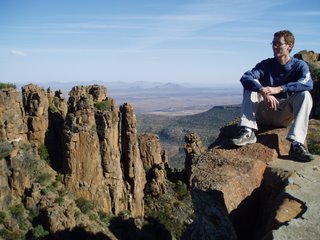
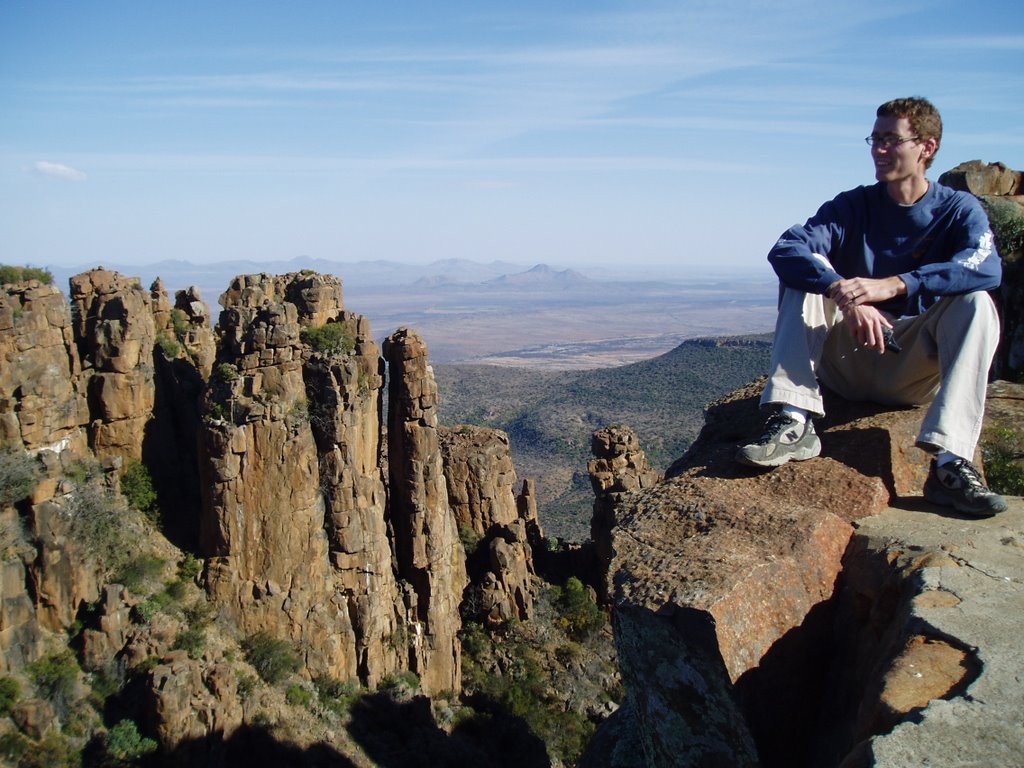
I am posting a picture from our trip. At the risk of being 'known' now, this was taken in Graaff-Reinet at the Camdeboo National Park in the Eastern Cape. Notice my Garmin in hand. Always.....
The Cape Town, Western Cape map that will be offered in gpstravelmaps.com shortly worked perfectly for the trip. It displayed all the roads we needed at the correct levels and helped me to log 17 geocaches while en route. I recorded tracks while out driving and hiking and will now incorporate those into the map to give even more detail.
Ryan has been hard at work back at the ranch developing the content to offer. He has made some good strides and we look forward to working with partners to offer more to everyone. Please let us know through the comments below if you have any particular ideas of needs for GPS maps in your area. We are looking for ideas, data, partners, etc.
I am posting a picture from our trip. At the risk of being 'known' now, this was taken in Graaff-Reinet at the Camdeboo National Park in the Eastern Cape. Notice my Garmin in hand. Always.....
07 July, 2006
Welcome
This is the blog of GPSTravelMaps.com. It is a website that is dedicated to providing cheap Garmin GPS maps to use while you are traveling. We have three maps currently available when the final site gets up and going. They are: Cape Town, South Africa - New York City, USA - Las Vegas, USA. We are also in the process of preparing transparent topographic maps for use over top of your normal GPS maps.
We have a lot of ideas and some cool stuff coming in the pipeline, so please be patient with us while we get this all sorted out and ready to go.
Stay tuned.....
We have a lot of ideas and some cool stuff coming in the pipeline, so please be patient with us while we get this all sorted out and ready to go.
Stay tuned.....
Subscribe to:
Posts (Atom)