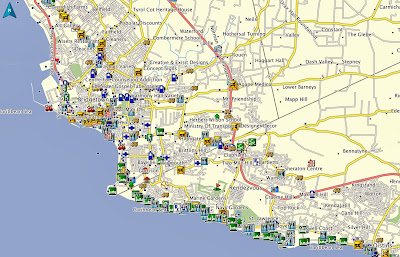
The
Barbados GPS Map from
GPSTravelMaps has been highly praised and useful to hundreds of residents and travelers to the island nation. Although
Barbados is a small island, navigation can be confusing at times, especially in the central and eastern parts where sugar cane agricultural roads can be like a maze.
The map may be purchased online and delivered immediately by clicking here.
Howard from Canada wrote in March 2013 "
I have been using the Barbados map which I purchased since February 26. Todate, I have found the map to be extremely accurate and very useful. The purchase and installation process were bother performed in a professional manner. I am totally satisfied with my purchase and highly recommend this product to anyone travelling to Barbados who is loooking for a GPS application". We are pleased to have been of assistance to travelers since January 2009.
The map has over 2,200 kilometers of roads with names associated to over 1,300 kilometers and oneway details on many road segments! The map contains over 2,000 unique POIs including
Hotels, Restaurants, Fuel Stations,
Tourist Attractions and
local businesses. In addition, detail on parks, lakes, rivers/streams,
golf, cemeteries, buildings and more geographic features to make navigation more enjoyable for the user.
 |
| Barbados comprehensive map detail |
 |
| Bridgetown street and POI detail |
 |
| Holetown road names and POIs |


